
North-east of Gyumri
About 23 km north-east of Gyumri · 22 km from our nearest station
- Date17 November 2026
- Time09:47 local · 05:47:11 UTC
- MagnitudeML 1.9 · Mw 2.7
- Epicentre40.954° N, 44.021° E
Located by the CHARNET network, IGES · 7 stations
North-west of Spitak
About 15 km north-west of Spitak · 27 km from our nearest station
- Date20 November 2026
- Time19:43 local · 15:43:05 UTC
- MagnitudeML 1.7
- Epicentre40.915° N, 44.133° E
Located by the CHARNET network, IGES · 6 stations
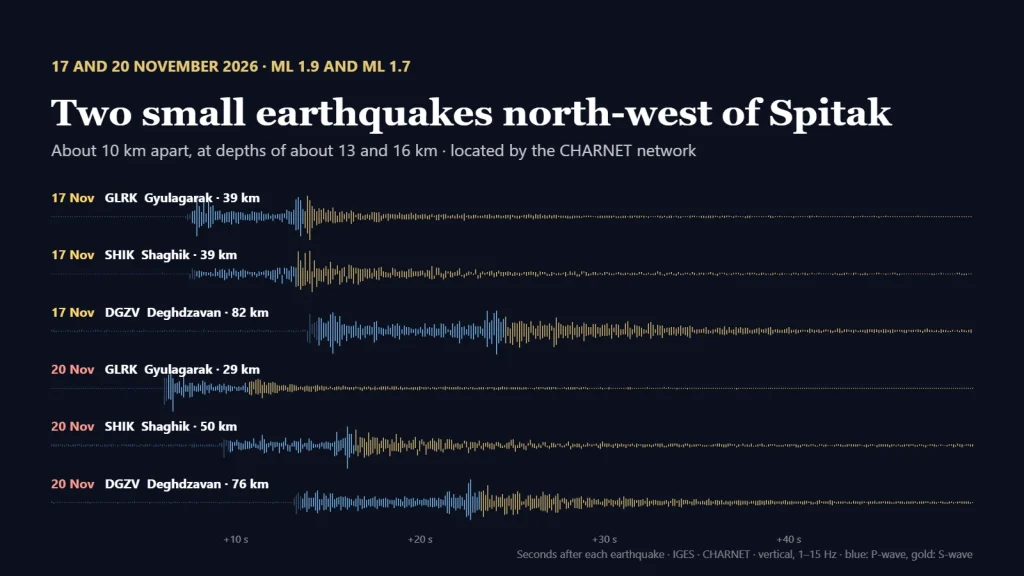
On 17 and 20 November, the CHARNET network located two small earthquakes in northern Armenia, north-west of Spitak. The first, of magnitude ML 1.9 (Mw 2.7), occurred at 09:47 local time on 17 November, about 25 kilometres north-west of Spitak and 23 kilometres north-east of Gyumri. The second, of magnitude ML 1.7, followed at 19:43 local time on 20 November, about 15 kilometres north-west of Spitak. The two epicentres are about 10 kilometres apart.
Unlike the recent earthquakes beyond our borders, both occurred inside the network, with stations on several sides of the epicentres and the nearest ones only 22 to 29 kilometres away. That constrains the locations better. In our solutions the foci are at depths of about 13 km and 16 km, although with so few stations depth is the least certain of the parameters. Seven stations were used to locate the first earthquake and six to locate the second.
The two epicentres (stars) and the CHARNET stations in the area (triangles). Elpin, the farthest station used, lies south of the map.
Below are the records of both earthquakes, from the nearest station shown to the farthest. Stations with more background noise are not shown. Press play to watch the waves arrive; the Z, N and E buttons switch between the vertical and the two horizontal components. You can also listen to each earthquake as Gyulagarak recorded it, sped up five times.
1–15 Hz, 65 seconds of record (05:47:10–05:48:15 UTC), shown 4× faster. Blue — the P-wave, gold — the S-wave. Sound: Gyulagarak station, vertical component, sped up 5 times. Location and magnitude: IGES, CHARNET network, 7 stations.
1–15 Hz, 60 seconds of record (15:43:05–15:44:05 UTC), shown 4× faster. Blue — the P-wave, gold — the S-wave. Sound: Gyulagarak station, vertical component, sped up 5 times. Location and magnitude: IGES, CHARNET network, 6 stations.
The area north-west of Spitak lies in the zone of the Spitak earthquake of 7 December 1988. Earthquakes as small as these release very little energy; recording and locating them is part of the everyday work of the network.
More earthquake sounds recorded by our stations: Listen to the Earth.
Catch the first wave
The same record, drawn by pens on a paper drum. Press the button, wait, and press again the moment the first wave arrives.
Can you catch the moment the earthquake arrives? Seismologists do it every day.