
North of Maku, Iran
About 24 km north of Maku · 56 km from our Elpin station
- Date18 November 2026
- Time20:42:16 UTC · 00:42 in Yerevan
- MagnitudeML 2.5 · Mw 3.0
- Epicentre39.512° N, 44.553° E
Located by the CHARNET network, IGES · 5 stations
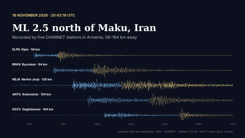
At 20:42 UTC on 18 November (00:42 on 19 November in Yerevan), a small earthquake of magnitude ML 2.5 (Mw 3.0) occurred in north-western Iran, about 24 kilometres north of the town of Maku and some 30 kilometres south-east of Mount Ararat. Five CHARNET stations in Armenia recorded it, from Elpin, 56 km away, to Deghdzavan, 194 km away.
The epicentre lies outside our network, to the south of Armenia, so all our stations see it from one side. That makes the location less precise than for earthquakes inside the country, and the depth, about 11 km in our solution, is poorly constrained. The arrival times at Deghdzavan, the farthest station, were not used in the final location.
The epicentre (star) north of Maku and the five CHARNET stations that recorded the earthquake. Hover over a station for its distance and S–P time.
between the P- and S-waves
Below are the records of the five stations, from the nearest to the farthest. Press play to watch the waves arrive; the Z, N and E buttons switch between the vertical and the two horizontal components. You can also listen to the earthquake as Elpin recorded it, sped up five times.
1–15 Hz, 65 seconds of record (20:42:20–20:43:25 UTC), shown 4× faster. Blue — the P-wave, gold — the S-wave. Sound: Elpin station, vertical component, sped up 5 times. Location and magnitude: IGES, CHARNET network, 5 stations.
The area between Mount Ararat and Maku lies in the same zone of collision between the Arabian and Eurasian plates as Armenia. Earthquakes beyond our borders, like this one, help us test how well the network locates events from every direction.
More earthquake sounds recorded by our stations: Listen to the Earth.
Catch the first wave
The same record, drawn by pens on a paper drum. Press the button, wait, and press again the moment the first wave arrives.
Can you catch the moment the earthquake arrives? Seismologists do it every day.