
Turkey–Iran border region
About 160 km south of Yerevan
- Date21 November 2026
- Time01:25 Armenian time (22 Nov) · 21:25:53 UTC
- MagnitudeMw 4.4 · IGES ML 4.5
- Epicentre38.76° N, 44.68° E
Location and magnitude: KOERI via EMSC · Records: CHARNET network, IGES
Turkey–Iran border region
The first of the three
- Date21 November 2026
- Time23:21 Armenian time · 19:21:10 UTC
- MagnitudeM 3.7 · IGES ML 4.0
- Epicentre38.82° N, 44.64° E
Location and magnitude: EMSC · Records: CHARNET network, IGES
Turkey–Iran border region
The third of the three
- Date21 November 2026
- Time01:42 Armenian time (22 Nov) · 21:42:22 UTC
- MagnitudeMw 4.0 · IGES ML 4.1
- Epicentre38.77° N, 44.68° E
Location and magnitude: EMSC · Records: CHARNET network, IGES
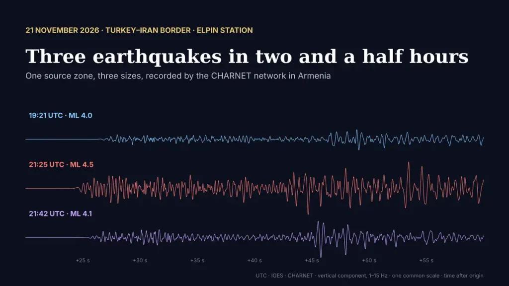
On the evening of 21 November three earthquakes occurred close together in the Turkey–Iran border region, about 160 kilometres south of Yerevan. According to the EMSC, the first, of magnitude 3.7, struck at 19:21 UTC (23:21 Armenian time); the strongest, Mw 4.4, at 21:25 UTC (01:25 on 22 November in Armenia); and the third, Mw 4.0, seventeen minutes later. All three were recorded across our CHARNET network.
The three epicentres located by our network: the star marks the strongest, ML 4.5 at 21:25 UTC, the coloured dots the other two. Dashed rings show the same earthquakes as located by the EMSC. The map zooms in to the epicentres after a few seconds; the button switches back to the whole network. Hover over a station for its distance and S–P time.
between the P- and S-waves
Why our epicentres differ from the EMSC
The IGES epicentres lie 15 to 34 kilometres south-south-west of those published by the EMSC. The reason is geometry: the earthquakes occurred outside our network, and all our stations see them from the north. With no stations on the other side, the location can slide along the direction of view, and the depth cannot be determined at all. Our automatic bulletins state this openly, with the lowest quality class and the note “event is located outside seismic net”. For earthquakes beyond Armenia’s borders, catalogues that combine stations from several countries, such as the EMSC, give the more reliable position; our records add precise arrival times and show how the shaking reached Armenia.
One source, three sizes
Our network places the three epicentres within about 14 kilometres of one another, the EMSC within about 7, and their records look alike at every station: the same sequence of waves, at the same times after the origin. They are not exact copies, which would mean the same patch of fault breaking again, but they clearly come from one small source zone. What differs is their size. At most stations the 21:25 earthquake shook the ground two to three and a half times more strongly than the first one, about half a unit of magnitude, in line with the IGES local magnitudes of 4.5 and 4.0.
Below are the records, with distances from our epicentres, from the nearest station to the farthest. Press play to watch the waves arrive; for the strongest earthquake the Z, N and E buttons switch between the vertical and the two horizontal components.
1–15 Hz, 72 seconds of record (21:26:08–21:27:20 UTC), shown 4× faster; each trace is scaled to its own maximum. Blue — the P-wave, gold — the S-wave, as picked in the IGES bulletin. Location and magnitude: KOERI via EMSC; IGES ML 4.5.
1–15 Hz, 70 seconds of record (19:21:25–19:22:35 UTC), shown 4× faster; each trace is scaled to its own maximum. Blue — the P-wave, gold — the S-wave, as picked in the IGES bulletin. Location and magnitude: EMSC; IGES ML 4.0.
1–15 Hz, 60 seconds of record (21:42:40–21:43:40 UTC), shown 4× faster; each trace is scaled to its own maximum. Blue — the P-wave, gold — the S-wave, as picked in the IGES bulletin. Location and magnitude: EMSC; IGES ML 4.1.
More earthquake records from our stations: Listen to the Earth.
Catch the first wave
The same record, drawn by pens on a paper drum. Press the button, wait, and press again the moment the first wave arrives.
Can you catch the moment the earthquake arrives? Seismologists do it every day.